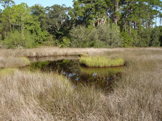
Ok, so this is Fort Mose. Fort Mose was established in 1738 just north of St. Augustine in Spanish Florida, named Gracia Real de Santa Teresa de Mose, as a haven for runaway slaves from the British Colonies. The slaves were given their freedom in this community in exchange for their service as militia and as the first line of defense against possible British invasion. Simple thatched houses were built inside the log and earth wall, and the surrounding fields were for their farms. War was declared between the British and Spanish in 1739, and in May of 1740, British soldiers from Georgia under General James Oglethorpe (remember him? See the Darien , GA post) marched south, and occupied Fort Mose, which had been abandoned as the inhabitants had fled to St Augustine. The British used this as a base to bombard St Augustine, and attack forragers who ventured outside the city walls. But on June 26, 300 Black Militia and Spanish soldiers under Francisco Menendez attacked and recaptired the fort, taking 34 prisoners and killing 68 British. The British retreated back to Georgia in 1942, and a Spanish counter invasion was defeated at St Simon's Island. The 1740 battle had destroyed the fort, but in 1752, it was rebuilt on slightly higher ground. This community thrived until 1763, when Florida was ceded to britain, and the residents of Fort Mose fled to Spanish Cuba. The actual sites are not accesible, as they are very ecologically and historically fragile, but a boardwalk leads to a viewing platform where the sites are readily recognizable. The above photo shows the site of the second fort. Below is a panoramic view from the platform. The site of the second fort is visible in the center of the photo. The site of the first fort is almost non-existant, and is partially blocked by the crop of trees in the right third of the photo.


This is an image I made using Google Earth to show what you are seeing in the above photos. The viewing platform is circled in blue. The lower red circle is the site of the first fort, where there is little physical remaining. The upper red circle is the second fort, which as you can see from the top photo, has enough remains to be clearly distinguishable from the surrounding swamp.

This photo is a butterfly I found on the way back, and below, a photo I particularly liked of the landscape leading out to the viewing platform.

 Ok, so this is the military museum, located in the Tovar House, part of the Oldest House Museum complex. Jose Tovar was an infantryman who lived in this house in 1763. During British rule, the house was owned by a Scottish merchant named John Johnson. When the Spanish took Florida back in 1784, the house was owned by a Canary Islander named Jose Caruna, and an assistant surgeon named Tomas Caraballo. Geronimo Alvarez, who lived next door in the Gonzalez-Alvarez House (last post) purchased the Tovar house in 1791. The entire property remained in his family until 1871. Above is an example of a Spanish explorer/soldier. The museum does not mention what artifacts are real and which are replicas, but given its condition, I would guess this is a replica.
 An early Air Force missle, probably a Falcon, representing the ongoing Air Force presence in Florida, most notably at Cape Canaveral and the Air Force Ordinance Test Center at Eglin AFB near Pensacola.
 An old Civil War era gattling gun.
 Speaking of the Civil War...
 This is the Tovar house. The fence/wall on the right side of the photo runs over to the entrance building tothe museum complex, where another wall connects it to the Gonzolez-Alvarez house.


